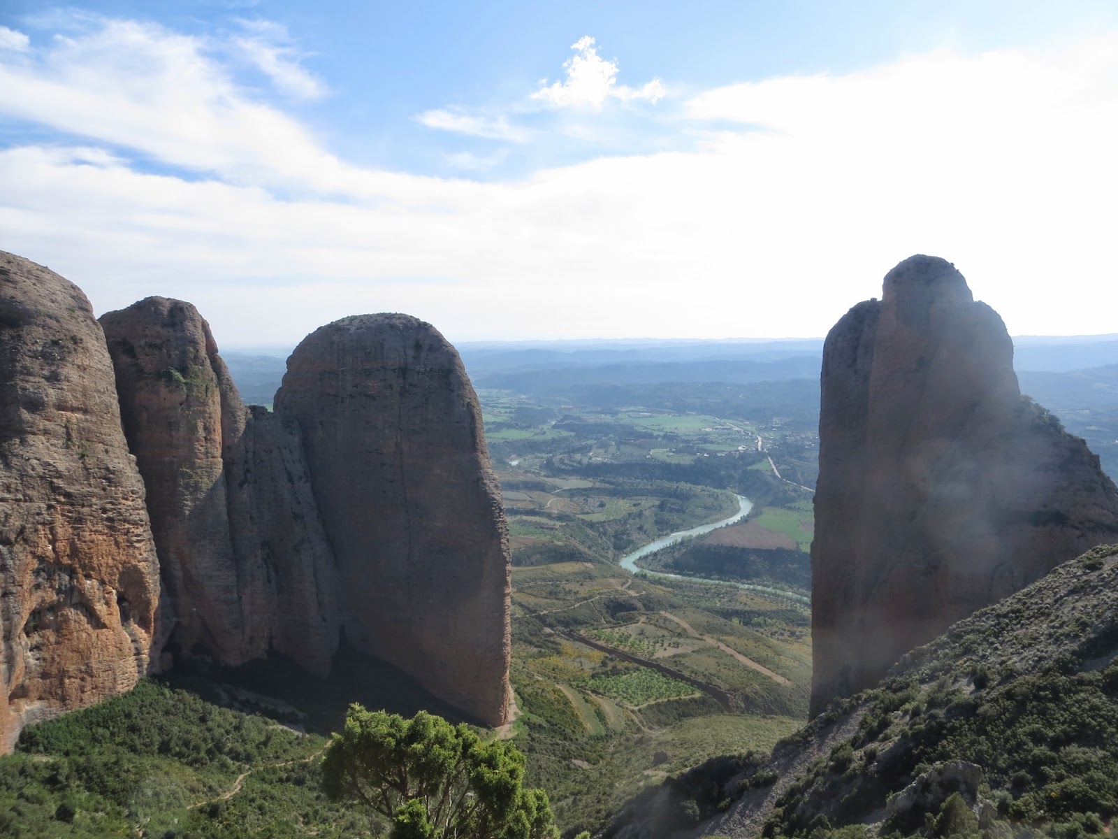
I was trying to think of some suitably impressive words to use to describe Riglos, but I can't so here's a photo instead:
 |
The towers are about 300m high and are made of variously sized pebbles stuck together by a sandstone matrix. Close up, they look improbable, like a large pile of rubble that should fall down, but somehow doesn't. It's also home to the largest colony of griffin vultures in Europe - they circle around catching updrafts from the towers, making the place feel even more atmospheric.
We spend just under a week here, and were joined by Naomi (who also visited us earlier in Chulilla) and Charles (a climbing partner of Andy's from the Cheddar days). Andy and Charles had their sights set on some of the classic overhanging routes on Mallo Visera (Andy wrote about this here), so Naomi and I went exploring.
We had great fun on several days playing the fortunately/unfortunately game. It's not really much of a game - you just describe things that happened to you prefacing anything that went wrong with "unfortunately" and your solution to the problem with "fortunately". It amused me though, so I thought I'd write about our adventures in this style...
Day 1: unfortunately, on Naomi and Charles' first day there was a speed climbing competition going on in Riglos - routes had been allocated a certain number of points, and participants had to collect as many points as they could in a 12 hour period. This meant that the classic routes on the main towers were busy. Fortunately, the Mallos Pequeños (the smaller towers to the east of the main ones) were not included in the climbing competition, so we decided to head there instead. Pequeño is a relative term - the towers were still 100m high!
 |
| Mallos Pequeños (Aguja Roja is the one on the right) |
 |
| Crazy rock, before the rain... |
 |
| ...and after |
Day 2: with an earlier start, a more stable weather forecast and an absence of speed climbers, we set our sights on a bigger objective on the main Riglos towers - the Travesia de las Cinco Puntas del Mallo Firé (also graded 4+). The Firé is the west-most of the main towers, and has a distinctive, many-peaked ridge line along the top. Unfortunately, as seen from the east during the walk up from the village, it looks intimidating and impenetrable.
 |
| Mallo Firé |
Fortunately, there's a sneaky easy route round the back that allows access to the ridge at an amenable grade. From there, the route goes to the top of peaks Montolar, Mallefré, Mateo and the tiny subsidiary peak of Buzón, before finishing on the slightly disappointingly named Punta de No Importa.
 |
| Unfortunately, our rope was too short to get all the way to the end. Fortunately, I decided this was close enough... |
Unfortunately, taking in so many peaks meant that the route was quite complicated - lots of climbing up, abseiling back down, and some devious route finding. Fortunately, we formed an efficient and honed climbing team so this was no problem - we ticked off all the peaks, enjoyed some amazing views, saw some vultures and made it back down in time for a lovely meal at the Refugio.
Day 3: unfortunately, after the exploits of day 2, we were both tired. Fortunately, it was a lovely day and the shop in Riglos sold ice cream. We lazed in the sun taking many photos of Andy and Charles climbing the normal route on the Mallo Puro (it was Charles's last day so they'd decided to push through the tiredness). Unfortunately (for them), we mischievously decided to steal their shoes. Fortunately (for them), it turns out I'm not very good at subterfuge, and tend to crack under the pressure of devious questions such as "what's in the bag?" I don't think I'm cut out for a career as a spy...
Day 4: Charles had to leave, so Naomi and I teamed up with Andy to climb Moskitos, a seven pitch route on Mallo Visera. This is a sneaky route that gets you into some similar positions to the famous harder routes up this wall (Fiesta de Los Biceps and Zulu Demente - see Andy's blog), but weaves around to avoid most of the steepness so is a much more amenable grade (6b/6b+, depending on which guide you read). The first few pitches were really fun: some interesting crack climbing, followed by an airy traverse across to the 'Trone', a car-sized boulder improbably wedged two-thirds of the way up the tower.
Unfortunately, the sun hit the crag at this point, and we'd all underestimated the effect of the heat on climbing performance. The crux pitch leaving the Trone was a bit of a struggle and I had to pull on pretty much all of the bolts to get up it. Fortunately...erm......I made it in the end, we didn't have to do a complicated abseil retreat, and I learned a valuable lesson about the importance of staying hydrated... The walk down from the top was spectacular.

We were ravenous when we got down, so enjoyed some well-earned tapas and ice cream at the bar, and watched some base jumpers being silly...
Day 5: exhausted! We drove to Santa Ana, near Lleida, intending to do some more conventional single-pitch sport climbing, but instead ended up eating tasty food and paddling in the (very cold) river.
Overall, Riglos was an experience - a spectacular place, and a very different style of climbing from what we were doing before. I left feeling very inspired to come back in the future, but will have to get a lot fitter first!!
Day 3: unfortunately, after the exploits of day 2, we were both tired. Fortunately, it was a lovely day and the shop in Riglos sold ice cream. We lazed in the sun taking many photos of Andy and Charles climbing the normal route on the Mallo Puro (it was Charles's last day so they'd decided to push through the tiredness). Unfortunately (for them), we mischievously decided to steal their shoes. Fortunately (for them), it turns out I'm not very good at subterfuge, and tend to crack under the pressure of devious questions such as "what's in the bag?" I don't think I'm cut out for a career as a spy...

|  |
| Mallos Puro (the pointy bit on the left). Andy and Charles are just reaching the top - can you see them? | |
Day 4: Charles had to leave, so Naomi and I teamed up with Andy to climb Moskitos, a seven pitch route on Mallo Visera. This is a sneaky route that gets you into some similar positions to the famous harder routes up this wall (Fiesta de Los Biceps and Zulu Demente - see Andy's blog), but weaves around to avoid most of the steepness so is a much more amenable grade (6b/6b+, depending on which guide you read). The first few pitches were really fun: some interesting crack climbing, followed by an airy traverse across to the 'Trone', a car-sized boulder improbably wedged two-thirds of the way up the tower.
 |
| Naomi on the traverse pitch of Moskitos |
Day 5: exhausted! We drove to Santa Ana, near Lleida, intending to do some more conventional single-pitch sport climbing, but instead ended up eating tasty food and paddling in the (very cold) river.
Overall, Riglos was an experience - a spectacular place, and a very different style of climbing from what we were doing before. I left feeling very inspired to come back in the future, but will have to get a lot fitter first!!


